Written by: Ahood Abdullah Al-Maimani
Publishing Date: 17th June 2012
VIDEO
The video is in uploaded on youtube in the link bellow
http://www.youtube.com/watch?v=B3FnmdGelms&feature=youtu.be
ABSTRACT
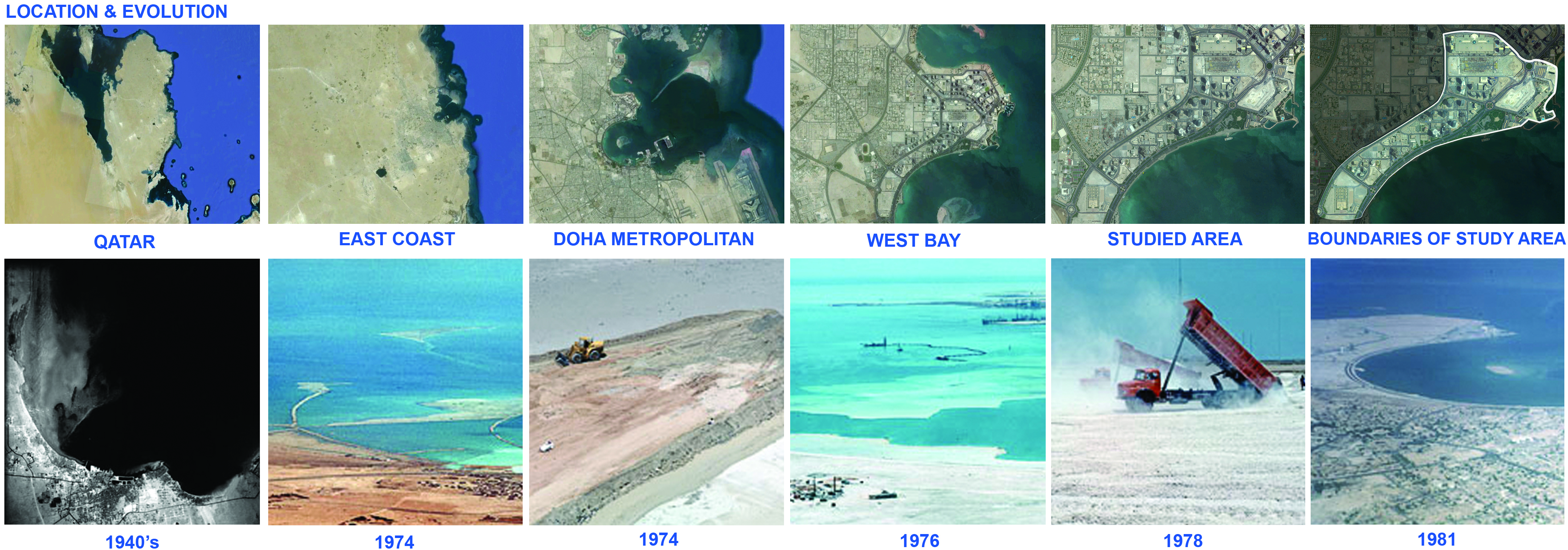
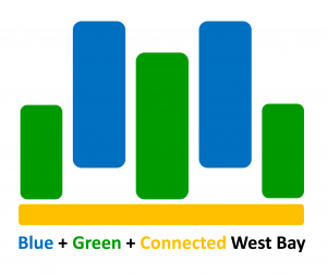
Located in the center of the city of Doha as a central business district (CBD), West Bay was very different in the past. In images show that in 1940’s the area was shallow, and only in 1974 the work started to create the New District of Doha using dredged material, to reclaim this new area. By the year 1978, the state had 2,000 hectares to build large number of facilities. The future plans for the area include multiple high-rise towers, automated people mover system, 25,000 underground parking, Sheraton park, and a convention center. These plans are long term, and do not address the current issues of the area. The areas face social imbalance problems, level and time of activeness issues between the area alongside the Cornish and the area the hosts the towers. This retrofitting plan proposes short-term solutions that work with the future plans, encouraging connectivity and integration and promote a live environment, creating a (Green + Blue + Connected West Bay).
1. SITE: LOCATION AND EVOLUTION
The area is located in the east coast of Qatar, in the center of the city of Doha as a central business district (CBD); West Bay was very different in the past. In 1940’s the area was shallow and not cleansed by the water currents running down from North. In 1974, two bunds were created to shape the New District of Doha, and then the area was dredged using dredged material to reclaim a new area from the sea which the government will develop. By the year 1978, the state had 2,000 hectares to build large number of facilities as: Qatar University, Regional Park, senior staff housing, Intermediate staff housing, Hotel of 500 beds and conference center, Diplomatic area, Ministries area, District center, and a Central business district. The New District of Doha was seen as an opportunity to establish high standards of design and construction within the State.
2. ANALYSIS: FUTURE PLANS AND CURRENT CONDITIONS
2.1. Future Plans:
A. Multiple High-rise Towers
B. Automated People Mover System
C. Underground Parking with capacity of 25,000
D. Sheraton Park
E. Convention Center
These plans are long term, and do not address the current issues of the area. The areas faces social imbalance, level and time of activeness between the area alongside the Cornish and the area the hosts the towers.
2.2. Current Conditions:
A. The Area Alongside the Cornish
The following are few comments from observations of several visits:
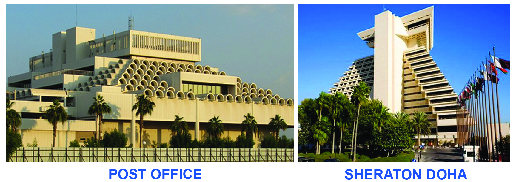
- Sheraton Hotel and the Central Post Office are landmarks from different historic timelines in the area.
- The area is pedestrian friendly, and also encourages cycling by creating special paths in a small area.
- It is a family destination where different activities happen, such as (walking, relaxing, having a snack, enjoying a picnic, playing in the playground).
- The environment is clean, green with a lot of landscape areas, hence fresh air.
- A good destination for sport activities with a long strip for jogging and exercising. In addition of hosting several sport events throughout the year such as (jet ski and water formula competitions).
- The lack of public beaches in Doha city drive a lot of users to visit Cornish, even though it has no actual beach, but only a view to the sea.
B. The Area of Towers
- A 6 lanes high speed highway separates the area from the he area alongside the Cornish, limiting the pedestrian access to it, even though there are pedestrian crossing signals in certain areas. These signals are not encouraging or inviting, especially for families with children.
- High presence of male construction workers because of the construction of high rise towers in the area which needs large number or labors. The issue is present in providing public spaces for these workers in the area, for waiting, socializing and enjoying breaks. As it was noticed that workers were enjoying the view to the Cornish from far away.
- The areas is not pedestrian friendly with very narrow or no pedestrian walkways, construction material and leftovers on the pathways, cars parked on the streets, which is dangerous as it was observed that many people are crossing the street by running trying not be hit by cars. With all this, tracing of bikes and shoe prints were visible in some areas indicating the potentials of making the area more pedestrianized.
- The area is polluted with construction leftovers, garbage, and high usage or vehicles producing CO2.
- Un-completed landscape projects were visible in many towers sites. As, only few Buildings Cared About Green Areas, (Tornado, Twisted, Doha) Towers.
- Interesting things to View
- Empty lots were used as parking areas, indicating the issue of lack of parking areas and high dependency of vehicles, as if the area was more pedestrianized, the need of parking may decrease.
The image below shows all these observations located on the map allowing a clear vision of the current situation.
3. VISION
3.1. Defining Retrofitting
Making a city green without tearing it down. Integrating energy-efficient technologies into cities without clearing away what’s already there. Additionally, it is a project on previously-built sites, to improve water quality in nearby streams, rivers or lakes. Also taking care of cogeneration of energy in urban areas that produces a potential of district heating. Impervious surfaces (such as parking lots and rooftops) generate high levels of storm-water runoff during rainstorms, damaging nearby water bodies. Storm water retrofitting includes rain gardens, permeable paving and green roofs. Suburban developments can be redesigned into more urban and more sustainable places.
3.2. Vision Statement
Blue: Water is a valuable source in Qatar, with its harsh climate and type of land (desert); hence it is an essential element to consider in large scale and small scale projects. Water is a source of life, and where there is water there is life. Recycling water is critical and needed.
Green: Soft-scape helps clearing the air, as with the large number of cars in the district, it is important to maintain a healthy level of CO2. Also using renewable energy, and promote recycling of waste and especially the organic waste and fertilizing the land.
Connected: Bridging both sides of the district (Cornish line and the Towers built area), creating more public open space as livable life for users of different ages, gender, backgrounds.
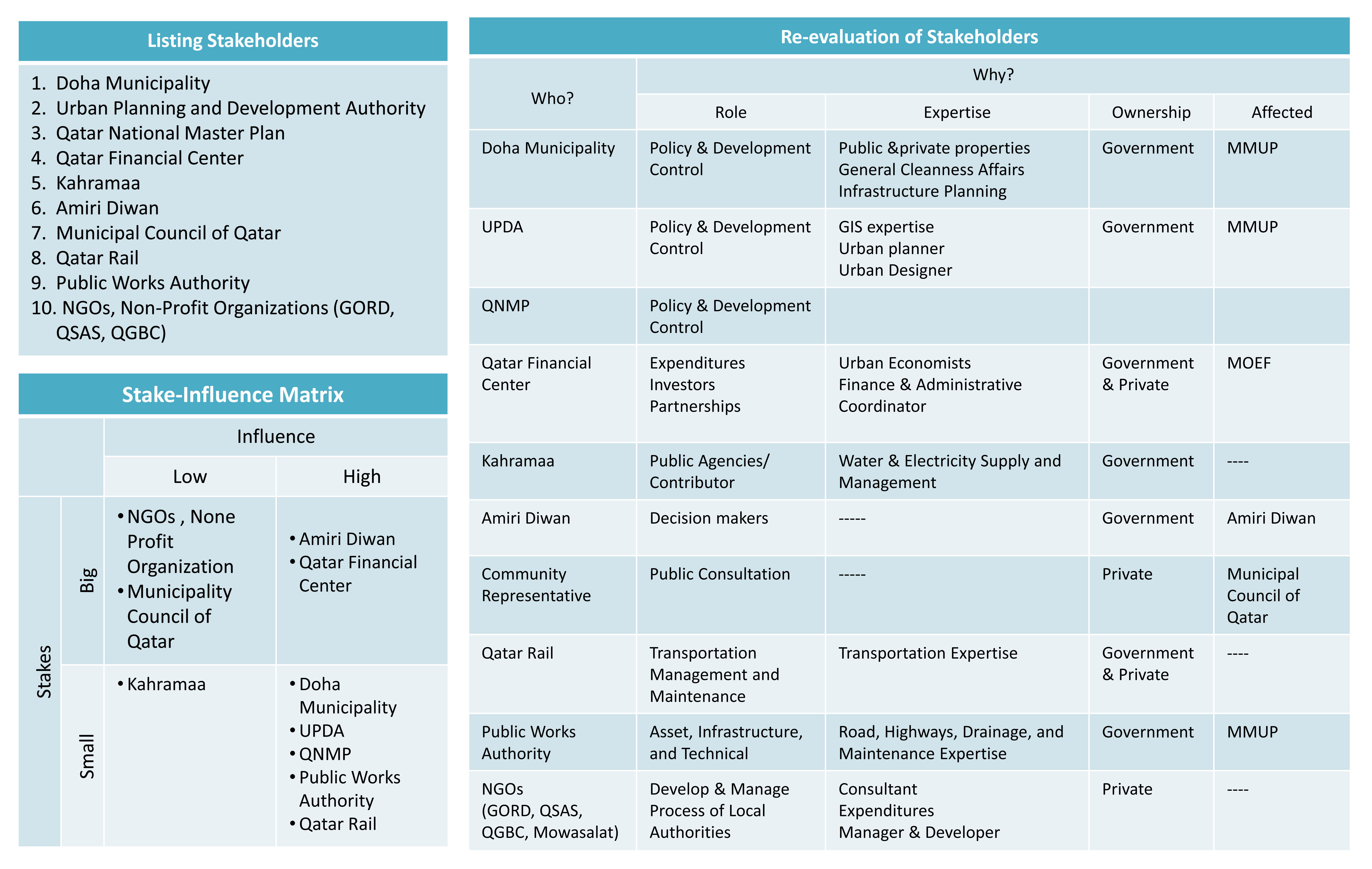
4. STAKEHOLDERS
The table below is an explanation of expected stakeholders; defining their role, required experts, and more.
5. STRATEGIES
The strategies bellow are specifically serving the vision for the retrofitting plan.
Blue:
B1: Creating a Beach Front for Public from Sheraton Hotel to the Post Office
B2: Creating More Beach Oriented Activities and Events.
B3: Using Zone Grey Water Treatment System
B4: Using Zone Rain Water Treatment System
Green:
G1: Renewable Energy (Solar Power, and Wind Power)
G2: Increase Planting in Towers Area By Law Creating a Green Belt Using Local Plants
G3: Separating Waste, Specifically Organic Waste that can be Used to Fertilize the Land.
Yellow
C1: Connecting Related Towers (Businesses, Ministries, … etc)
C2: Connecting Cornish with Towers Area
C3: Adding Bike Paths
C4: Adding Cafeterias that will Gather People in Different Times of the Day
C5: Adding Playgrounds for Children
C6: Changing the Function of Doha Sheraton to a Youth and Convention Center
C7: Integrating the Post Office More with the Active Area
6. PROPOSED PLAN
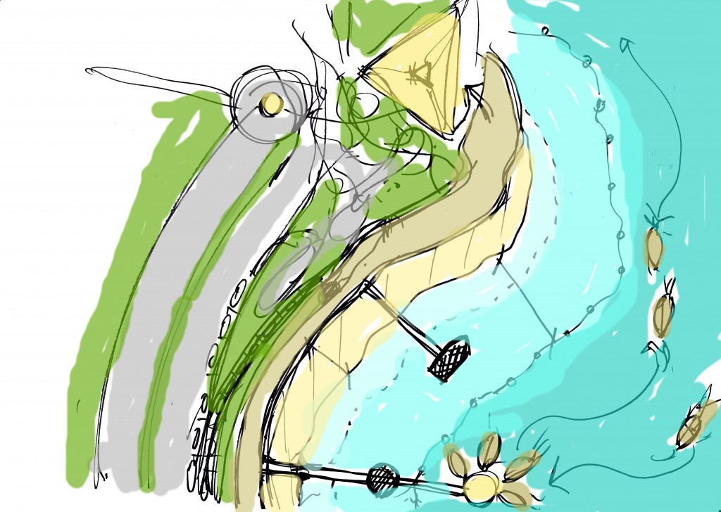
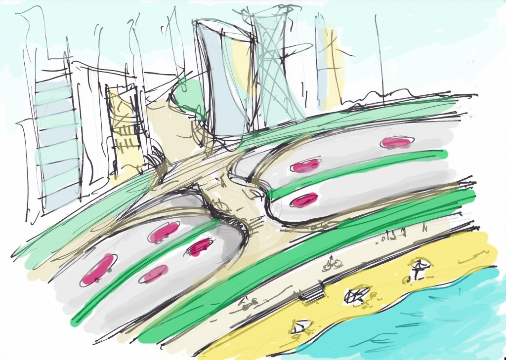
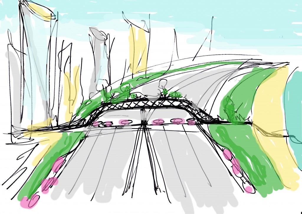
The sketches below illustrate the general theme of the proposal, focusing on the two historical landmarks, the beachfront, connection bridges and more.
6.1. Master Plan

6.2. Implementation Phases
Since the proposed plan is a short term plan, it will be implemented but not limited to the actions below in three phases. Also, these phases work with the future plans of the area:
Phase 1:
1- Cleaning up the water front, and preparing it for landfilling with sand, and start landfilling.
2- Closing up the beach front to start preparing for building the docks where restaurants are located, and for the boats.
3- Starting the closing up of streets in where the open public spaces are located in the towers area.
4- Start working on the connection bridges.
5- Preparing the land for plantation near the post office.
6- Defining the cycle path routs and start working on them.
7- Preparing the Sheraton Hotel for use change and partial evacuation.
8- Setting policies for grey water and rainwater system, and renewable energy for property owners.
Phase 2:
9- Finalizing beach landfilling.
10- Continue working on the docks.
11- Start working on the open spaces shown in the plan.
12- Continue working on the connection bridges.
13- Continue working on the park near the post office.
14- Finalizing the cycle path routs.
15- Start internal rehabilitation of Sheraton Hotel by providing it with necessary changes for the new use.
16- Informing property owners with the new policies, encouraging them by incentives.
Phase 3:
17- Finalizing and opening the docks and restaurants.
18- Finalizing and opening the open spaces, their playgrounds and restaurants/cafe’.
19- Finalizing and opening the connection bridges.
20- Finalizing and opening the park with its playground and restaurant/cafe’.
21- Finalizing and opening the New Youth Center for public use.
22- Distributing the separate waste bins in proper locations.
23- Make sure new policies are implemented.
POSTER
Thanks
© 2012 Ahood Al-Maimani All Rights Reserved



I genuinely enjoy your web page, even so I’m having a difficulty: anytime I load 1 of your post in Safari, the right with the webpage is screwed – it’s strange. May I mail you a screenshot? Anyways, continue your very good job; I truly appreciate reading you.
Usually I do not read post on blogs, however I would like to say that this write-up very compelled me to take a look at and do so! Your writing style has been amazed me. Thank you, quite nice article.
Really intriguing information !Perfect just what I was looking for!
thanks.http://www.acertemail.com