From the regional plan to New York and its Environs (1929) – Clarence Perry
Author
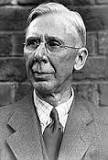
fig 1 Clarence Arthur Perry
Clarence Arthur Perry was an American planner, sociologist, author, and educator. He was born in Truxton, New York. He later worked in the New York City planning department where he became a strong advocate of the Neighborhood unit.
SUMMARY
In the 1920s, early in the automobile age, American architect Clarence Perry thought deeply about the way in which the growth of cities and the rise of the automobiles were affecting neighborhoods and characteristics that make good neighborhoods.
He articulated a philosophy for maintaining human-scale neighborhoods in the modern world that has had a profound impact on twentieth century urban planning and remains extremely relevant nowadays.
Every great city is a conglomerate of smaller communities.
He wrote about the cellular city. The “cellular city “ is the inevitable product of the automobile age. It is the quality of life within these smaller communities that will most shape individuals’ experience.
Perry noted that in the past many people felt a strong identity with villages and small towns, a perception shared by the new urbanists. But by the time, Perry wrote that the express highways were cutting up residential areas into small islands separated from each other.
He also noted that the primary school was the central institution to which nuclear families with young children related. The quality of the school was the most important factor in deciding which school district to live in, and the location of the house in relation to school affected home buying choices. Perry argued that neighborhood units should be built around schools.
Author’s Introduction
What is known as a neighborhood, and what is now commonly defined as a region, has at least one characteristic in common. They possess a certain unity, which is quite independent of political boundaries.
In the planning of any large metropolitan area, we find that three kinds of communities are involved:
- The regional community
- The village, country or city community
- The neighborhood community
While the neighborhood community has no political structure, it frequently has greater unity and coherence than are found in the village or city.
The residential communities, when they meet the universal needs of family life, have similar parts performing similar functions.
In the neighborhood unit system, those parts have been put together as an organic whole.
An urban neighborhood should be regarded both as a unit of a larger whole and as a distinct entity in itself.
There are certain other facilities which are strictly local to a well-arranged residential community. They may be classified under four heads:
- The elementary school
- Small parks and playgrounds
- Local shops
- Residential environments
Neighborhood Unit Principles
- Size(housing for population/ one elementary school)
- Boundaries(wide major streets on all sides)
- Open spaces(small parks/ recreation spaces)
- Institution sites(schools and other institutions)
- Local shops(one or more shopping districts in the circumference of the unit)
- Internal street system(a special street system to facilitate circulation within the unit)
For each of these principles, it is desirable to obtain a clearer of them, and for that purpose, a number of plans and diagrams in which they have been applied will be presented below.
Low-cost Suburban Development
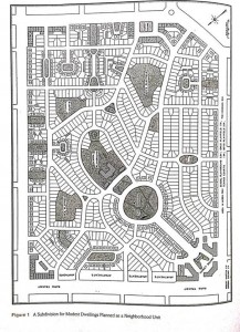
fig 2 Low-cost Suburban Development
- Character of district
- Population and houses
822 single-family houses
236 double houses
147 apartment suites
1,241 families (4.93 persons/ family)
- Open spaces
Parks, playgrounds, small greens = 10.6% of the total area
- Community center
Schoolhouse
Two lateral structures
Small central plaza
Sites provided for two churches
Market square
- Shopping districts
Small shopping districts on the four corners
Parking
Small market squares
- Street system
Boundary streets (120-feet wide / 160-feet side)
Interior streets (40-50-feet wide)
A Neighborhood Unit for an Industrial Section
fig 3 A Neighborhood Unit for an Industrial Section
- The functional dispositions
Northern border: high industry, garages, warehouses
Sides: apartments
- Housing density
Based on a housing scheme providing for 2000 families
8,800 people
- Recreation spaces
Large schoolyard
Two playgrounds
- Community center
Group of structures – centrally located
Capacious school
Two churches
Small square
- Shopping districts
Small market square around the main portal, along the southern arterial road
- Economic aspects
Use of land without the usual loss of comfortable living environment
Apartment House Unit
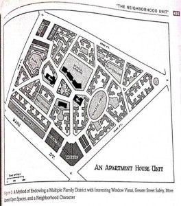
fig 4 Apartment House Unit
- Population
5 story and basement building, and allowing 1,320 sqfeet/suite:
2381 families, 4.2 persons/family
10,000 population
- Environment
Downtown business establishments and the residences
begin to merge
- Street system
Bounded by wide street
Narrower interior highways
- Open spaces
Parks and playgrounds: over one acre/1,000 persons
School yards: 89 sq feet/1 pupil
Large athletic field
Seeded recreational spaces
- Community center
A group of: a school, two churches, public building
Formal treatment
- The suites are four, five, six and seven roomsApartment pattern
As a rule, light comes from 3 parts
Every apartment looks out upon a central garden
Five-block-apartment-house-unit
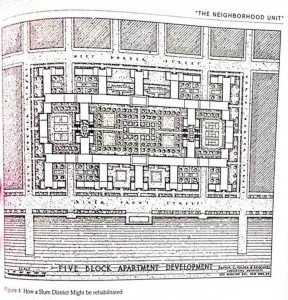
fig 5 Five-block-apartment-house-unit
- Locality
The blocks = 200 feet wide and 670 feet long
- Ground plan
Dimensions: 650 feet by 1,200 feet
53% of the total area is devoted to open spaces
- Accommodations
1,000 families, with suites ranging from 3 to 14 rooms
Elementary school, auditorium, gym and other athletic facilities
First floor of certain buildings devoted to shops
- height
2-3 stories on the boundary street
10 stories in the abutting ribs
15 stories in the main central ribs
33 stories in the 2 towers
Relevance to the City of Doha
As a local case study, Musherib neighborhood (Doha- Qatar) will be discussed briefly below, with some assisting photos and graphs. The figures show the division of zones based on their functions (the land use), the heights (fig 9) and the urban fabric of the neighborhood.
The Msheireb is a 35 hectare mixed-use masterplan for the regeneration of the historic heart of Doha. The masterplan role has developed to include several major architectural projects, including the public buildings which form the Diwan Amiri Quarter, the first phase of residential and community buildings, the National Eid Ground and a sculptural enclosure for the city’s first sustainable cooling plant.
Based on the principles of the neighborhood unit that Perry mentioned in the previous article, I tried to make a relationship and check if all the principles are existed in Musheirib.
- Size(housing for population/ one elementary school)
As shown in (fig 10), the zone which is highlighted with brown colors indicates the residential area. In addition to that, I made a search about if there is any elementary schools in musheireb. Results showed that there were some design proposals for a new primary school in Doha, Qatar, as part of the Msheireb masterplan development. The school will offer an integrated learning environment for 450 students.
- Boundaries(wide major streets on all sides)
They are clearly shown in figure 7, 9 and 10.
- Open spaces(small parks/ recreation spaces)
Musherib project offers many spaces for recreation such as areas for sport activities, heritage quarters and others, in addition to many green areas.
- Institution sites(schools and other institutions)
Shown in figure 10.
- Local shops(one or more shopping districts in the circumference of the unit)
Shown in figure 10.
- Internal street system(a special street system to facilitate circulation within the unit)
Shown in figures 7 and 10.
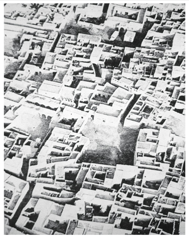
fig 6 A traditional fareej (the concept of Musheirib Project)
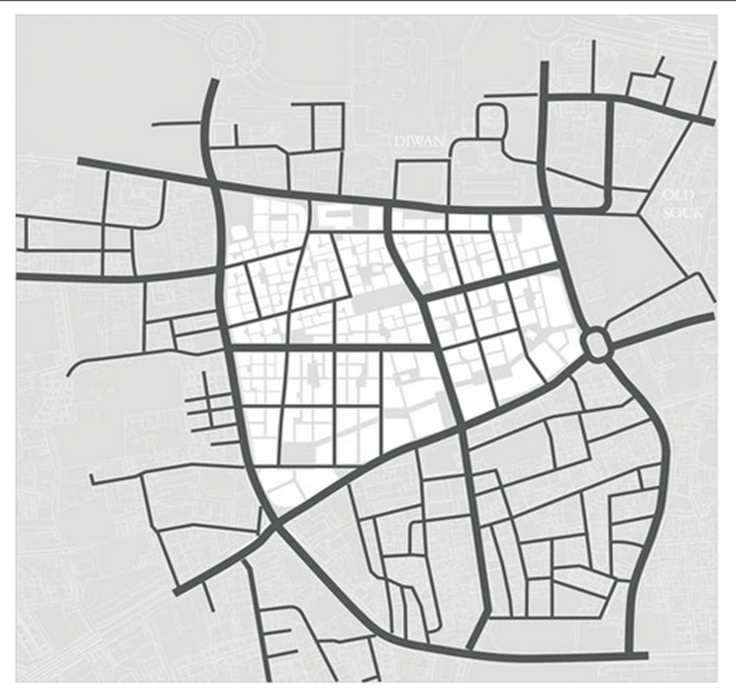
fig 7 The urban fabric of Musheirib
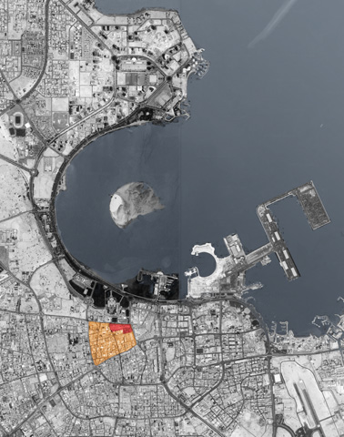
fig 8 An aerial view of Doha showing the Musherib location

fig 9 An aerial view showing the different heights of the buildings in Musheirib project
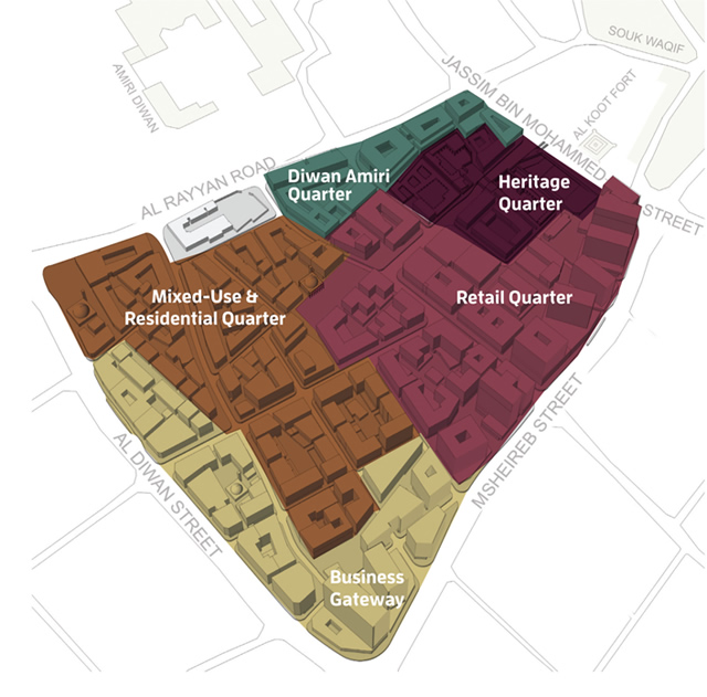
fig 10 The master plan of Musheirib project showing the land use of each zone